Stuðlagil or Studlagil basalt column canyon and how to get there
- Einar Páll Svavarsson
- Apr 25
- 9 min read
This is the first article written about Stuðlagil Canyon. It was published in 2016 and has been reviewed several times for updates. Most of the information in other articles and travel blogs comes from this article.
In 2016, my discovery of Stuðlagil, also known as Studlagil in English, marked the beginning of a transformation for this hidden gem in Iceland. Through my extensive research, writing, and photography, I unveiled the beauty of the canyon and brought it to the attention of locals and tourists alike. Before my exploration, Stuðlagil was unknown, tucked away from the eyes of those wandering through Iceland's breathtaking landscapes. Delving deeper into the canyon's history, I uncovered the intriguing tale of its evolution from a glacial river to a spring-fed waterway due to the construction of a hydroelectric power plant. This narrative added another layer of fascination to this natural wonder. This fascinating narrative was published in a Wow Air Magazine in June 2017.

My discovery was later documented in a comprehensive 100-page report commissioned by the University of Iceland and the Icelandic Tourism Research Center, shedding light on the geological and environmental significance of Stuðlagil.
Adding Stuðlagil to Google Maps to assist you in locating it
To further facilitate access to this newfound treasure, with the permission of the landowners, I took it upon myself to establish the location of Studlagil on Google Maps, ensuring that enthusiasts and explorers could easily navigate their way to this picturesque spot. Despite the timeless presence of Stuðlagil's basalt columns, much of its enchanting landscape remained submerged beneath the waters of the Jökla River until recent years, a fact that adds a surreal quality to the experience of witnessing this natural marvel.

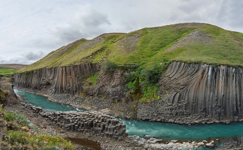
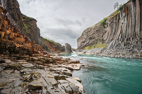
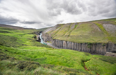
The enchanting marvel of nature and Stuðlagil basalt columns
Step into the stunning beauty of Stuðlagil Canyon! Imagine yourself standing beside the tranquil river, captivated by the graceful movements of birds against the impressive basalt formations' backdrop. Reflecting on the dramatic history that has shaped this landscape is truly fascinating. From a turbulent past to its current serene state, Stuðlagil stands as a testament to the incredible force of nature and the enchanting beauty that arises from its constant evolution. This destination is a must-see in Iceland, where time and nature come together to create an unforgettable experience that will leave you utterly amazed!

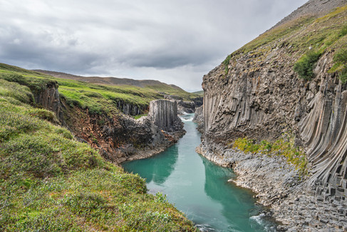
Studlagil canyon and Jökuldalur valley

Jökuldalur, or the “Glacier Valley,” is an impressive valley in East Iceland and home of Studlagil. Since early on, it has mostly consisted of sheep farms, some of which are considered among the best in the country. The valley is also known for its forceful glacial river that has three names: Jökulsá á Brú, Jökulsá á Dal, and Jökla, which forces its way down from the highland through the bottom to the valley for centuries. When heading to northern Iceland from Egilsstaðir in the Eastern Region of Iceland on the Ring Road, road no. 1, part of the road goes through the lower part of Jökuldalur valley. To enter upper Jökuldalur, you must turn south onto road no. 923 near the Skjödólfsstaðir farm. In upper Jökuldalur, you will find the breathtaking waterfall Stuðlafoss (basalt column waterfall) and the Stuðlagil canyon (basalt column canyon).
The terrifying river that kept Studlagil basalt column canyon hidden
The Jökulsá á Brú River, renowned for its impressive basalt column formations, was relatively undiscovered prior to 2016. This area, often referred to as the glacier river by the bridge, had been one of Iceland’s hidden natural wonders until the discovery of the Stuðlagil basalt column canyon attracted widespread attention. My writing and photography helped to popularize it as a significant tourist attraction, as noted by the Icelandic Tourism Research Center.
The mighty river and its role in dividing the farms
Historically, one reason for the limited visitation to this region was the formidable nature of the River Jökla. Stretching 150 kilometers, it was one of Iceland’s largest and most powerful glacial rivers until the construction of the Hálslón reservoir. Its strength caused it to divide the Jökuldalur valley, resulting in minimal communication between the two parts for centuries. Additionally, the river posed dangers that made crossing difficult, leading to its local designation as Jökla rather than its official name.
The reservoir that swallowed the glacial river

The powerplant that chanced the river
When Icelanders constructed the Kárahnjúkavirkjun hydroelectric plant and created the large Hálslón reservoir in the Hafrahvammagljúfur canyon, it changed the flow of the River Jökla. Instead of the river flowing freely as a glacial river through the beautiful Jökuldalur Valley and the stunning Studlagil Canyon, the water from its original sources in the northeastern highlands was redirected into the new reservoir. From there, the water travels through 60 kilometers of underground tunnels to power the turbines of the plant.
The water and the power of the vanished river
As a result, the sources of River Jökulsá á Brú no longer reach the Jökuldalur Valley; instead, they are diverted to the Fljótsdalur Valley. This project was undertaken to supply electricity to the aluminum plant in Reyðarfjörður. However, this large-scale alteration of the natural landscape sparked significant debate and controversy.
The sacrifice of building a power plant
The construction of the hydroelectric project in Iceland stirred deep emotional responses among its people. Many felt a profound sense of loss as the project significantly altered the natural landscape. The creation of the reservoir led to the submergence of cherished landscapes and natural wonders, forever changing the character of the second-largest river in Iceland. It was particularly heartbreaking for many to see the Töfrafoss waterfall vanish beneath the water's surface. Preservationists voiced their concerns about the 57-square-kilometer reservoir, highlighting the irreversible environmental damage inflicted on the unique landscape, its natural treasures, and the local fauna. Yet, amidst this loss, a strikingly beautiful feature emerged—the Stuðlagil basalt column canyon, a stunning natural wonder that had been hidden from view. This dual narrative reflects the complex emotions surrounding the project, as the community grappled with both sorrow and a newfound appreciation for nature's resilience.
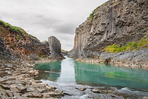
Stuðlagil is a ravishing natural wonder

Environmental changes from a glacial river to a spring-fed river
The transformation of the river Jökla is truly a poignant story that reflects the changing nature of our environment. Once a robust glacial river, it has undergone a remarkable shift, now drawing its lifeblood from springs and creeks nestled in the lower highlands and surrounding mountains. This change has had deep implications for the river itself, altering its volume and vigor. The powerful waters that once carried copious amounts of sand, mud, and debris from beneath the Vatnajökull glacier have given way to a serene, crystal-clear flow that gently winds its way to the sea.

A smaller glacial river in winter runs through Stuðlagil Canyon
As we observe this beautiful yet stark contrast, we can’t help but feel a sense of loss for the river’s former might, with its waters at a noticeably lower level and a gentler force. However, there is an enchanting turn of events each autumn when the river momentarily returns to its vibrant past. As the Hálslón reservoir reaches its capacity, glacial waters overflow from the mighty Vatnajökull ice cap, reviving Jökla and allowing it to carry echoes of its former self through the landscape of Jökuldalur.
Visit Stuðlagil at the right time
Though this resurgence typically comes in late August or September, the volume of water released is modest compared to what it once was. This cyclical transformation brings both beauty and melancholy, impacting how we experience the breathtaking area around Studlagil. The interplay between the river's past and present weaves a complex narrative into the natural landscape, reminding us of the fragility and resilience of Iceland's geological wonders. In all their dynamic splendor, these changes invite us to reflect on our connection to nature and the stories it tells.
Map of how you visit, drive, and hike to Studlagil Canyon

The drawbacks of the western side and why it's not worthwhile as it looks like a badly designed tourist trap.

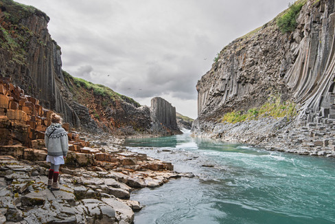
Accessing Studlagil can be done in two ways. The less favorable option is to drive to the Grund farm and observe the canyon from the west side, following a route that involves turning south on Ring Road no. 1 by Skjödólfsstaðir and then onto road no. 923 for about 20 kilometers until reaching the farm. At Grund farm, there is a parking lot available. However, the west side of Studlagil is far from being as impressive as the one at Klaustursel, and I outline it on the map above. At Grund, there is an oddly positioned observation platform that requires climbing 240 steps (equivalent to ascending and descending 18 floors in a building) and offers a very restricted view of the canyon's beauty. On this side, the owners have also damaged the surrounding area terribly. This site is under no circumstances recommended for photographers, as it is challenging or impossible to capture the true magnificence of the canyon from this angle. In contrast, hiking on the east side is a more pleasant experience compared to climbing numerous steps. Therefore, visiting the west side at Grund is considered a waste of both time and energy.
How to visit and hike to the stunning eastern side of Stuðlagil that I highly recommend.

The second option to view and experience Studlagil requires some hiking. It is such a short hike, as you can see on the map that the effort only adds to the enjoyment of visiting such a place. Again, after turning south on Ring Road no. 1 by Skjödólfsstaðir to road no. 923, drive about 14 kilometers to farm Klaustursel. Less driving is required to reach the Klaustursel farm than Grund. On River Jöklai, by Klaustursel, you find a bridge on the east side. By the bridge, there is a parking lot A on the west side. You can also drive over the new bridge, which is about two kilometers away, to another parking lot B on the east side and shorten the hike. After crossing the bridge to the east riverbank and the drive to lot B, hike for two kilometers to reach Stuðlagil Canyon. This is probably less of an effort and more interesting than climbing the odd stairs with a very limited view on the west side by Grund. You can see this more clearly on the map above.
Climbing down to the river on the east side of the canyon is possible at one spot and requires caution, but once down by the river, you sense that you have entered a wonder world of basalt columns. The stones and rocks are sometimes wet and slippery, so take precautions. The hike for both ways is six to eight kilometers, and reaching the stop by the canyon takes probably two to three hours. I recommend going to the canyon in the morning for photography. An excellent way to plan this visit is to stay at a Skjödólfsstaðir accommodation or campsite and get an early morning start. Stuðlagil is part of my Ring Road article.
When to visit Stuðlagil Canyon?

Visiting Stuðlagil Canyon in the summer, from the beginning of June until the second week of August, is advisable. In August, the hydroelectric reservoir's overflow sends part of the old, dirty glacial river down the river path. This occurs every year in the middle of August and changes this natural wonder substantially. In winter, the vibrant colors of the vegetation disappear, and the canyon becomes dull and drab and is often covered with snow and ice. It is not noteworthy for viewing or photography as in the colorful summer days when the river is turquoise instead of brown and dirty.
Accommodation close to and around Stuðlagil Basalt Column Canyon
Á Hreindýraslóðum Guesthouse: Found in East Skjöldólfsstaðir, this guesthouse offers single, double, and triple rooms with shared facilities, as well as a camping site and restaurant.
Gistihúsið – Lake Hotel Egilsstaðir: Located in Egilsstaðir, approximately 72 km from Stuðlagil Canyon, this family-run hotel offers a range of rooms, a restaurant, and a spa with views over Lake Lagarfljót.
Hotel Eyvindará: A peaceful hotel situated in a forested area near Egilsstaðir, offering cozy rooms and cottages, making it a convenient base for exploring the canyon and surrounding attractions.

Photos from 2016, before Stuðlagil became a popular tourist attraction, when it was a hidden gem in Iceland