Search Results
334 results found with an empty search
- Bárðarbunga huge volcano and glacier in Iceland
The last eruption Holuhraun lava field from Bárðarbunga volcano in 2014 Bárðarbunga is the second-highest mountain in Iceland, next to Öræfajökull and standing a little over 2000 meters tall. Like many mountains in Iceland, Bárðarbunga has many different faces. In addition to being a mountain, it is also an outlet glacier placed on the northwest side of the large ice cap Vatnajökull and covering the mountain and its surrounding valleys and canyons is an 800-meter-thick layer of ice. Gazing at the ice on top of Bárðarbunga is fascinating, and the glacier can be seen in all its greatness from the center of the Icelandic Highland. But what lies beneath is probably more interesting and potentially frightening. Not so deep under the mountain Bárðarbunga, waiting patiently, is a vast magma chamber full of glowing magma eager to surface. So, in addition to being a mountain and a glacier, Bárðarbunga is also a volcano. In addition to being the second-highest mountain is also the second-largest volcano in Iceland, with a volcanic system that is 200 kilometers long and 25 kilometers wide. The mountain holds a tremendous natural force that everyone hopes will never be released. So, when earthquakes occur in Bárðarbunga, everyone should be intimidated. Map of Highland in Iceland The scary magma beneath The lava at Holuhraun eruption One of the primary indicators predicting an eruption is earthquakes, which are caused by the magma moving around near the surface. The magma is like a giant red monster of a thousand degrees trying to find its way to the surface and simultaneously shifting the earth's crust, moving its many arms from the chamber into all the cracks, fissures, and crevasses it can find with the intention to surface with its tail extending deep into the Earth's core. It is considered a frightening beast and for good reason; the last time Bárðarbunga erupted was only a few years ago, in 2014. Fortunately for everyone, the eruption occurred on the sand only a few kilometers north of the Bárðarbunga glacier. Even though it was just another eruption in Iceland, it was one of the largest in modern history in relation to the volume of lava. If the monster had found its way under the glacier, only a few kilometers south, the story would have been entirely different and more like that of the Eyjafjallajökull eruption, but with more massive floods and possibly a natural disaster. Eruptions in Bárðarbunga and nearby places Youngest member og earths surface - basalt lava Although scientists predict devastating floods and even natural disasters, the effect could be less destructive if the beast surfaces under the glacier. In 1996, short but powerful eruptions occurred near Bárðarbunga in Grímsvötn. The eruption lasted for two weeks and melted a tremendous amount of ice, producing a massive flood that found its way to the southern shore instead of flooding to the north over the Highland. For Icelanders, the flood was a natural disaster with devastating effects on the landscape, with roads and bridges being the primary victims. Fortunately, no lives were lost. In addition to this eruption and the 2014 eruption, it is believed that a small eruption occurred in 1797. We are yet to see a large eruption in Bárðarbunga, but it would have devastating effects on the northeastern part of the country. Read this important article about renting a car in Iceland.
- Fimmvörðuháls one of Iceland's most popular hiking trail
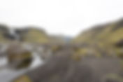
Hiking at Fimmvörðuháls Fimmvörðuháls, or 'The Five Cairn Ridge’, is one of Iceland's most popular hiking trails. Although the trail is quite challenging and can even be dangerous, many Icelanders and visitors hike this 22 km trail at up to 1000 meters in elevation every summer. The main reason, of course, is its stunning landscapes. It is simply a spectacular hike with spectacular views of many natural wonders: waterfalls, craters, canyons, glaciers, and a breathtaking view of the mountains of the Highland. The track runs in between two glaciers, Eyjafjallajökull and Mýrdalsjökull, and part of it is on snow. The track also goes through a crater, and, in 2010, a small eruption occurred at the track's most challenging section. Map of Highland in Iceland The track between two glaciers View at Fimmvörðuháls to Þórsmörk Most of the hikers walk from the well-known waterfall Skógafoss to Þórsmörk. From Skógafoss, you walk through fascinating landscapes with many small waterfalls on your left side of the river Skógá. The elevation is a bit steep all the way to a hut at the top. From there, it is more or less downhill all the way to Þórsmörk. Some hikers prefer to do the hike in one day, while others choose to stay at the hut and finish the hike in two days. At the peak, the track has a view of the east side of Eyjafjallajökull glacier and the west side of the Mýrdalsjökull glacier. Both glaciers house powerful volcanos that can erupt at short notice. Even the most notorious volcano in Iceland's cultural and geological history, Katla in Mýrdalsjökull, has been due to erupt since 2018, as it does every 100 years. Fimmvörðuháls is also often considered to be an extension of our famous Laugavegur hike, and many hikers finish their hike from Landmannalaugar at Skógafoss waterfall, adding the extra 22 kilometers to the 54 kilometer Laugavegur hike. Hiking Fimmvörðuháls requires caution Fimmvörðuháls view to Mýrdalsjökull glacier In 1970, a group of eleven hikers started the trail in good weather from Skógafoss, determined to walk to Þórsmörk. There was nothing exceptionally unusual about the weather or the conditions. At the top, near Heljarkambur, severe weather hit the mountain, and three hikers became exhausted and died within hours. The rest of the group made it to Básar in Þórsmörk with enormous hardship and difficulty. The story constantly reminds us of the unpredictable weather that the two glaciers can produce. It is also a reminder of the necessity of preparing thoroughly before hiking over Fimmvörðuháls and taking all possible precautions. The track is only accessible from late May until September and is only for highly trained and experienced hikers at any other time of the year. Know what to look for when you rent a car for your vacation in Iceland
- Eldgjá or 'Fire Canyon’
Eldgjá canyon in the Icelandic Highland If you have a 4X4 rental car while traveling in Iceland, you should consider taking a drive to Eldgjá. The name Eldgjá, or 'Fire Canyon’, refers to a 40-kilometer fissure in the Icelandic Highland stretching southwest from Gjátindur mountain all the way to the glacier Mýrdalsjökull, continuing under the glacier and reaching the fearsome volcano Katla. It is a geological wonder and, in essence, a volcano, seeing as much of the surrounding lava and vast lava carpets south of the fissure came from Eldgjá centuries ago. The name was given to the fissure by Iceland's first geologist Þorvaldur Thoroddssen, at the end of the 19th century. However, today and for the last half a century, the term Eldgjá has most often referred to a part in the middle of the fissure: the large and impressive canyon and natural wonder located at the Highland Road Fjallabaksleið Nyrðri. Map of Highland in Iceland A canyon with one of our most impressive waterfalls Overview of Eldgjá canyon and Ófærufoss Waterfall The popular part of the canyon Eldgjá is approximately 5 kilometers long and around 600 meters wide. The cliffs and slopes framing the magnificent natural wonder are more or less 200 meters high. In the middle of the canyon, the river Nyrðri Ófæra (‘The Impassable Northern River’) falls into the canyon as one of Iceland's most impressive waterfalls, Ófærufoss (‘The Impassable Waterfall’). A marked hiking trail exists from the mouth of the canyon, beginning at the parking lot and small service center. The walk to the waterfall is about 30 to 40 minutes. You can also walk up to a viewing deck by the middle of the waterfall to get up close and personal with Ófærufoss waterfall, which is, if I might say so, quite spectacular. Access to Eldgjá requires a 4WD vehicle Eldgjá hiking track Eldgjá is part of the Icelandic Highland. Like all other places in the Highland in Iceland, it is only accessible during the opening time of the Highland roads, from early July until the middle of September. Like with most Highland roads, it also requires a 4X4 vehicle as the road is a rugged dirt road, and, on your way to Eldgjá, you need to cross fords and unbridged rivers. The best way to access the road is from the Ring Road, around 23 kilometers west of the village Kirkjubæjarklaustur. Here you take a turn north on Road no. 208 and drive approximately 16 kilometers until you take a left turn and enter mountain road F208 Fjallabaksleið Nyrðri. On this road, you need to drive about 26 kilometers to reach Eldgjá. Know what to look for when you rent a car for your vacation in Iceland
- Fagrifoss waterfall in the Icelandic Highland
Fagrifoss waterfall Fagrifoss is a beautiful and impressive waterfall in the Icelandic Highland. Although not a mainstream tourist attraction, many tourists visit it as it is located on the road to Lakagígar. When you reach the waterfall and stand in front of it, you understand why it is called Fagrifoss or ‘The Beautiful Waterfall’. It is not a mainstream attraction because you need to drive a rough highland F-road to visit Fagrifoss, which requires a good 4X4 vehicle. It also involves river crossing; rivers in the Highland can be unpredictable and for people only used to asphalt roads and bridges on rivers, this can be difficult. However, if you are somewhat adventurous and prepared to spend the extra money on a 4X4 car in addition to driving at a speed of 15km per hour, you should defiantly visit this waterfall. Most of those visiting Fagrifoss also continue along the Highland Road to Laki, Tjarnargígur, and Lakagígar: the craters that produced most of the surrounding lava in the massive eruption in 1784. Map of Icelandic Highland Among the highest waterfalls in Iceland Viewing Fagrifoss Fagrifoss is 80 meters high and is located in the river Geirlandsá. Although in the Highland, the waterfall is not far away from the famous Fjaðrárgljúfur canyon. There is a good parking lot and a small toilet/restroom near the waterfall in an area that seems to be all flat when you drive through it. The spectacular waterfall is almost impossible to see until you stand in front of it, but when you approach, a deep gorge opens below where the river Geirlandsá falls. You can view Fagrifoss from the edge of this gorge, and just recently, an observation platform was set up which gives a fantastic view: probably the best spot to enjoy the magic of such a natural wonder. Access is difficult but offers a new kind of fun if you are careful Fagrifoss waterfall The waterfall Fagrifoss is located just a few meters from Lakavegur or mountain road F206. While it is part of the Icelandic Highland, it is only 17 kilometers from Ring Road No. 1. On the south shore near the small village of Kirkjubærjarklaustur, you turn north on the Ring Road to Holtsvegur, Road no. 206. This is the same road you drive to visit Fjaðrárgljúfur canyon. After driving just two kilometers, you turn north again to the Lakavegur Road No. F206 that will lead you to Fagrifoss. Know what to look for when you rent a car for your vacation in Iceland
- Hvanngil valley in the Highland in Iceland
For centuries, sheep farmers in Iceland have sent their stock into the wilderness, the Highland, to wander during summer, graze in the mountains and spare the farmland for harvesting in late summer. So, one of the main reasons our ancestors started to enter the Highland, the backland of the island's interior, was because of the annual gathering of sheep. They send the sheep in spring to the Highland, and in autumn, flocks of selected individuals from each region and farm travel to the Highland to find and gather their sheep. Early on, those trips to the Highland were a test of manhood and were well sought after by young men. The trips were often quite difficult as the weather in Iceland has always been quite unpredictable. Also, and until the last century, places to accommodate or find shelter overnight were fewer and rarely habitable. Most of those places were either caves or even holes in the ground. But as things developed, Icelanders started to build huts in the Highland for the ones who stayed up there for three days, gathering sheep and often walking great distances to search for their sheep in the backland. Map of Highland in Iceland Hvanngil was originally a place for farmers for gathering their sheep The hut and camping at Hvanngil Hvanngil is a small valley in the Highland and is a well-known place for its popular hiking trail, Laugavegur. It was initially one of the places where farmers built their huts in the middle of the ninetieth century to stay in the Highland while gathering sheep in autumn. At that time, the huts were built to accommodate a group of searchers upstairs while sheep were downstairs. For those curious about such houses, the yellow hut is still intact in Hvanngil. Later, around the seventies, the last century, travel clubs started to build cabins only aimed at housing the Highland travelers who were there for fun and enjoyment. At Hvanngil, one was built in the eighties and is one of the best huts in the Highland. For those hiking, Laugavegur, Hvanngil is an attractive place to stay and those who want to take time to drive the difficult Highland Road, Syðri Fjallabak. There are also several exciting hiking trails around the hut into the magnificent Torfajökull area. How to get to Hvanngil To visit Hvanngil you need to crss large rivers Hvanngil is only reached by a well-equipped 4X4 vehicle. It is only possible to visit this place from the middle of July until late September. Even in September, one can expect snow. So, this is a place for serious hikers and travelers in Iceland who understand how to travel in the Highland and know how to cross rivers. It is a part of the mountain road F210, one of the most challenging highland roads in Iceland. It is highly recommended to find a local guide and a driver if you are interested in visiting this part of the Highland in Iceland. Know what to look for when you rent a car for your vacation in Iceland
- Gýgjarfoss waterfall
Gýgjarfoss waterfall There are not many waterfalls in the Icelandic Highland that have become popular or significant attractions. One of the reasons is the relatively short time that the Highland in Iceland is open: only from the middle of June until the middle of September. However, that doesn't mean that Iceland lacks spectacular waterfalls in the Highland, with waterfalls like Fagrifoss, Ófærufoss, and Sigöldufoss being good examples. Another reason is the difficulty of accessing many waterfalls in the Highland, with some requiring a long hike to reach and enjoy. One of the beautiful waterfalls in the Highland that is reasonably accessible is Gýgjarfoss, located close to the Highland road Kjalvegur or Kjölur. If you are on Road no. F347 leading to Kerlingarfjöll and Hveradalir you will drive by Gýgjarfoss. Since both Kerlingarfjöll and Hveradalir have become popular due to easier access and road construction in the Highland, the waterfall has in turn become more popular. Map og Highland in Iceland Gýgjarfoss has spectacular surroundings Gýgjarfoss waterfall close to Kerlingafjöll mountains in Highland Although the waterfall is only about 5 meters high and around 20 meters wide, it is fed an impressive volume of water from a powerful source. The waterfall is in the river Jökulfall which has its source in the glacier Hofsjökull, the mountain ridge Kerlingarfjöll and many small spring-fed rivers. Eventually, the river joins the mighty river Hvítá, which provides the stream for our most spectacular waterfall Gullfoss. The flood can vary depending on the season, with more volume during spring and early summer. Sometimes, on a warm day the flood is much more in the afternoon than in the morning. The area surrounding Gýgjarfoss is quite impressive, with the mountains in the background, a fascinating gorge downstream and glaciers both to the east and the west; it is a wonderful place for photographers. The riverbanks by the waterfall also make an interesting foreground for photography. It is an interesting waterfall to stop by when you are on your way to Hveradalir and absolutely one of the more spectacular places to visit in the Highland. Quite accessible during summer, although a 4X4 is recommended Gýgjarfoss waterfall is a convenient part of the Kjölur or Kjalvegur road trip. When driving along Road no. 35 and turning to Kerlingarfjöll and Hveradalir, the waterfall is as close to the road as possible. If you are interested in seeing this waterfall, there are many other marvellous natural wonders you will see on that magnificent scenic drive in the Highland. Know what to look for when you rent a car for your vacation in Iceland
- Hafrahvammagljúfur in the northeast part of the Highland
Hafrahvammagljúfur canyon Although sometimes referred to as one canyon, Hafrahvammagljúfur in the northeast part of the Highland is actually two canyons, Hafrahvammagljúfur and Dimmugljúfur. And even though the attraction is a spectacular natural wonder, the history of the canyon, both the geological history and its place in modern Icelandic history, is also fascinating. Hafrahvammagljúfur is about 25 kilometers north of the Vatajökull icecap and stretches north towards the valley Jökuldalur ('Glacier Valley’). The canyon has 200-meter-high walls but is only about 100 to 150 meters in width, making it seem narrow and intimidating as everything is dark and steep. It is believed that the river Jökla dug the canyon over millions of years through the palagonite layer and formed it with some help from other natural forces. The river was the second most powerful river in Iceland for thousands of years. You have to be impressed when you stand in front of a natural wonder of this magnitude and scale and realize that it was made with flowing water. Map of Highland in Iceland Just recently, Man stepped in with his engineering know-how Kárahnjúkar dam at Hafrahvammagljúfur Icelanders have been quite clever in building hydroelectric power plants and utilizing their rivers to produce electricity for more than a century, but not without controversy. Many Icelanders and political parties have viewed the rivers as a key to progress for a long time: a place to produce electricity rather than a natural wonder to view and enjoy. Inevitably, many Icelanders looked to the mighty river Jökla as a logical selection for a power plant. It wasn't until the eighties and nineties that this prospect became real, and the power plant Kárahnúkavirkjun took a leap from the drawing board into reality. The decision went hand in hand with the building of the huge aluminum smelter you see right outside the small fishing village Reyðarfjörður. The aluminum smelter was the ‘customer’ who purchased the electricity. It was a massive project that changed the path of the river and the view of the canyons, not to mention the size of the mighty glacial river that became relatively small and spring-fed. A dam was built across the canyon to collect water in a huge reservoir which simultaneously covered beautiful waterfalls, part of the canyon, and other unrecoverable natural wonders. It goes without saying that the project initiated an avalanche of disputes between conservationists and those who wanted to sacrifice the natural wonders for the dam and electricity for the aluminum smelter. There are pros and cons, but most people might stop and wonder Mt. Kárahnjúkar and the dam and new reservoir Although Hafrahvammagljúfur and Dimmugljúfur are two canyons and part of the spectacular landscape of Iceland, the whole project provokes serious questions. Approaching the canyon on an asphalt road deep in the Highland is a bit odd for anyone who loves Icelandic nature. This was a profoundly remote place only a few years ago, and you could not travel from the east side of the mighty river Jökla to the west side, both because of the canyon and the river. Today you cross the canyon on a concrete road over a dam. On the other hand, for many residents in the small, declining fishing villages in the eastern region, it was a welcome boost for the economy of the area and a worthwhile sacrifice for them to have the option of continuing to live where they most prefer. Furthermore, compared to other energy sources around the world, it is clean, renewable, and not threatening the planet like fossil fuels. It is a fascinating subject and one that is appropriate to think about when you visit the canyon and view the dam and the reservoir. Access is quite simple today The Kárahjúkar dam Access to Hafrahvammagljúfur is quite simple. From the town of Egilsstaðir in the Eastern Region, you drive south on Road no. 1, the Ring Road. About seven kilometers south, you take a turn to the east to Road no. 931 all the way over the bridge and take a turn to the south again on Road no. 933. You drive a short distance on 933 and turn onto Road no. 910 and drive all the way to Hálslón, the new reservoir by Kárahnjúkar.
- Hvítárvatn lake in the Highland
Hvítárvatn lake in the Highland in Iceland Some lakes in Iceland, probably around five or six, are placed by the edge of a glacier. All those lakes receive water from the melting glaciers and glacier tongues and, in many cases, from spring-fed water flowing from mountains hidden under the ice cap. In some cases, the lake is full of icebergs fallen from the glacier tongue, like the famous Icelandic tourist attractions Fjallsárlón and Jökulsárlón. Hvítárvatn (White River Lake) is one such lake in the Highland near the highland road Kjölur (Kjalvegur/Road Nr. 35), which is located by the glacier Langjökull and the glacier tongue Norðurjökull. In addition to the above-mentioned sources, the lake is fed by rivers and creeks in the surrounding area. However, icebergs are seldom seen on this lake or lagoon. One of the main reasons is that the glacier tongue or the outlet glacier is dead and doesn't reach the lagoon anymore. Map of Highland in Iceland As the primary source is glacial rivers, the lake always looks a bit milky, which probably contributed to the name. The size is approximately 30 square kilometers, and the average depth is about 30 meters, with the deepest part reaching around 90 meters. Hvítárvatn is placed at an altitude of 420 meters and is the main source for one of Iceland's largest rivers—Hvítá (White River). In Hvítá, to the south of the lake, is located Iceland's most spectacular waterfall—Gullfoss. The haunted hut and the young female ghost: The haunted hut at Hvítárnes Located near the lake, mountain hut Sæluhúsið í Hvítárnesi is one of the many huts in the Highland. It is famous for being one of the most haunted places in Iceland. The cabin was built in the 1940s. According to many stories, complaints, and reports from the 1940s to the present, a young female is often seen in the hut. Many guests, particularly male guests, complain about disturbances from a young female ghost while in the transitional state of consciousness between wakefulness and sleep. Many visitors have also claimed to have seen her in one of the windows when arriving late at night and then learning that the house was empty. A particular bed in the hut is believed to be exceptionally unsafe and almost impossible to sleep in: Apparently, on many occasions, guests have been kicked out of the bed during the night by "no one"! It is a mysterious place and a challenge for adventurers who dare to "sleep in her bed." Access to Hvítárvatn is not for small cars: Hvítárvatn lake by the glacier Langjökull If you drive from Reykjavík or the southern part of the Ring Road along the south shore to Gullfoss, you are basically on the road to Hvítárvatn when you pass Gullfoss. The road is quite rough, and a robust 4X4 vehicle is recommended, especially for the dirt road that takes you to the shoreline of Hvítárvatn. Know what to look for when you rent a car for your vacation in Iceland
- Jarlhettur mountain ridge
Jarlhettur The mountain ridge Jarlhettur (The Earls Cap) is easily visible in southern Iceland from many places and many angles. The ridge is 15 kilometers in length and comprises 20 mountains where each peak is similar to the next, although the height and diameter differ. It is a spectacular sight that can be seen while driving the Golden Circle, with the ice cap Langjökull glacier in the background. The ridge direction is the same as most geological fissures in the area, and in Iceland for that matter—from southwest to northeast. The best visibility is toward the east side, where you have the glacier Langjökull in the background—a perspective that always interests photographers. It is almost odd to find the name Earl in the Icelandic landscape since Iceland hardly ever had any real Earls governing the land or the people. On the other hand, Icelandic Vikings traveled a lot to Europe and were acquainted with Earls and Kings. Map of Highland in Iceland Jarlhettur mountain ridge is in contrast with many natural wonders in Iceland: Jarlhettur at sunset in winter The mountains are of palagonite nature and almost entirely lack vegetation. The lakes and small rivers at the bottom of the mountains contain glacial waters, so everything is gray and looks like another planet. This contrast with many of the magnificent natural beauties in Icelandic nature makes Jarlhettur ridge fascinating. Most of the mountains are around 800 to 900 meters high, but the highest one, Tröllhetta or Troll Cap, is a little less than 1100 meters. Most of the mountains are barely climbable as the surface of the steep palagonite mountains is made of small rocks. However, those who dare and succeed to climb enjoy a spectacular view. Access to the breathtaking view of Jarlhettur requires an excellent 4x4 vehicle: Jarlhettur There are mainly two ways to see Jarlhettur in proximity. One is to drive from Þingvellir National Park, located north on the road Uxahryggjavegur (Road Nr. 550), and turn on the rugged mountain road Skjaldbreiðarvegur (F338). On the second part of this drive, a few kilometers before you reach Kjalvegur, you will have an excellent view of Jarlhettur in the north. The second way to reach the proximity of Tröllhetta is to visit the Nýifoss waterfall and Hagavatn. You can take this drive from near Gullfoss waterfall and a short drive on Kjalvegur. Know what to look for when you rent a car for your vacation in Iceland
- Kerlingarfjöll mountains for hiking and camping in the Highland
Kerlingarfjöll mountains Kerlingarfjöll (the old woman's mountains) is an exciting place to visit in Iceland and a must-visit place if you are planning to travel to and looking for things to do in the Icelandic Highland. The cluster of rugged mountains is placed in the middle of the Highland. Most of the mountains are steep and around 800 to 1500 meters high. Although all the mountains have their individual names, they are usually referred to by their common name, which is rare in the Icelandic landscape, as most mountains have their own identity. This is probably because the mountains were barely visited and feared for centuries, as they were believed to be the hiding place of outlaws. However, from the early 1970s, Kerlingarfjöll became popular as a ski resort during summer. The place also had a skiing school, which discontinued its operation at the end of the previous century due to the retreating of the glaciers. Nevertheless, despite all the glaciers, this is the only go-to place in Iceland for skiing during summer. Map of Highland in Iceland A feast for photographers and joy for hikers: Mountains Kerlingarfjöll seen from Gígjarfoss The mountain cluster Kerlingarfjöll is a paradise for both hikers and photographers. Many convenient and scenic hiking trails lead to it from the camping ground and a small hotel at Ásgarður. A short distance from Ásgarður, there is even a tiny geothermal pool conveniently situated in a small canyon. Most of the mountains are basalt, like in most places in Iceland, but there is also a large area of beautiful rhyolite mountains. One of the most exciting parts is Hveradalir, where colors vary along the track depending on the weather, mostly the sun, to a point where it almost becomes unreal and you slip into a state of hypnosis. Although the altitude of most of the trails is about 1000 meters, there is a surprising amount and variety of vegetation. On most of the tracks, the view is stunning, with two large glaciers and a big part of Kjalvegur road. How to find and reach Kerlingarfjöll: Mountains Kerlingarfjöll seen from Gígjarfoss For years, the road to Kerlingarfjöll was a 4X4 trail with two to three rivers to pass. You could only drive there on a modified 4X4 vehicle. However, today, the rivers have bridges, and you can drive to Ásgarður, the camping site, and the service center in a small 4X4 vehicle. The best way to drive to Kerlingarfjöll is to take Road Nr. 35 Kjalvegur road from Gullfoss and drive approximately 55 kilometers to the highland road to Kerlingarfjöll. When you turn to the east on F347, the distance to Kerlingarfjöll is only 10 kilometers. We recommend an overnight stay for at least one night and an early morning hike for a few hours. Here, you must remember that the highland roads are open only from early June until late September. So, the window to enjoy this magnificent landscape is only about three to four months each year. Know what to look for when you rent a car for your vacation in Iceland
- Kverkfjöll remote mountains in the Highland
Kverkfjöll is one of the most remote places in the Highland in Iceland Deep in the northeast region of the Icelandic Highland, you will find a remote and fascinating place called Kverkfjöll, located north of Vatnajokull ice cap, the largest glacier in Europe. It is a captivating site that reveals the combination of ice and magma and how both forces constantly work together in shaping Iceland. The magma lurking under the ground heats the ice above the surface, filling it with the warmth that melts the ice from beneath. This phenomenon forms ice caves at the edge of the glacier. In few places are the consequences of the combination of fire and ice more obvious. Kverkfjöll is home to Iceland's largest geothermal area, warm geothermal pools, chilling ice caves, and challenging hiking paths and a harsh landscape between glacier tongues Brúaárjökull and Dyngjuökull, which regularly exhibit signs of possible eruptions. Kverkfjöll is a place for passionate hikers seeking real-life adventures and interested in visiting the most exotic sites in Iceland. It is not a place to visit for a quick selfie, but rather a place that demands proper preparation and good gear. It is a place for outdoor enthusiasts who like to hike, ski, and climb fascinating mountains. Map of Iceland Highland Kverkfjöll is a place of many options: At the edge of Vatnajökull glacier As part of the Icelandic Highland, it is a highly sensitive place. The area is always a bit wet and lacks vegetation. Mostly covered with snow for a large part of the year, the Kverkfjöll mountains are only accessible during the months of July through September. Even in those three months, extreme care must be exercised when visiting. Owing to its many attractions and natural wonders, Kverkfjöll has a good service center, an accommodation option, and a camping area. It is an "out of this world" place to visit—but harsh and unpredictable. Access is not easy and requires a full-size 4X4 vehicle: At Kverkfjöll you will find an interesting camping site To drive to Kverkfjöll, you need a large 4X4 vehicle, such as Toyota Hilux, Toyota Landcruiser, Land Rover, or Jeep Rubicon. The roads cannot be traversed with a small 4X4 as some of the roads are difficult and there are rivers to cross; these rivers can change rapidly with rain or change in temperature. The best route is to drive from Mývatn lake toward the east on Road Nr. 1 and take the mountain road Öskjuleið (F88). After driving approximately 75 kilometers—among other places, by Herðubreið, the queen of Icelandic mountains—you turn on the mountain road Austurleið (F910). After driving around 12 kilometers on F910, you take another turn on the mountain road Kverkfjallaleið (F902). After about a 40-kilometer drive, you are at Sigurðarskáli cabin in Kverkfjöll. Overall, it is about a 130-kilometer drive into the most remote area in the Icelandic Highland—a natural wonderland of landscape, geology, and photography. Know what to look for when you rent a car for your vacation in Iceland
- Langisjór the most beautiful lake in Iceland
One of our favorite places in Iceland, Gunna my wife sitting by Langisjór Langisjór lake is part of the vast outback area in Iceland, called Fjallabak. The lake is located deep into the Icelandic Highland and is often viewed as a bit mysterious. Moreover, it is one of the largest natural lakes in the country and not a reservoir for a hydroelectric plant, unlike many lakes in the Highland. The lake is a bit difficult to view unless you either travel to the edge of the water or climb a nearby steep mountain. However, this challenge only enhances the lake's charm. It is in my view the most beautiful lake in Iceland. Map of Icelandic Highland Hidden until the 19th century: Standing on the top of Mt. Sveinstindur viewing Langisjór to the north Owing to the distance from the shoreline and lowland, throughout history, no one traveled this deep into the Highland or ever wrote about this lake until the middle of the 19th century, when it was discovered. The lake is 20-kilometer long and only two-kilometer wide, which is the reason for the name Langisjór (the long sea). On both sides of the lake, two long mountain ridges, Fögrufjöll (beautiful mountains) and Tungnaárfjöll, embrace the lake. In the late 19th century, the first geologist in Iceland, the prominent Þorvaldur Thoroddsen, traveled to Langisjór and viewed the lake from the same place where this photo was taken (on top of the mountain Sveinstindur [Sveins peak]). Later, in his report, he named the lake and the mountain; it is noteworthy that he named the mountain after his friend and travel companion, who was a physician. A difficult place to visit: Lake Langisjór in the Highland in Iceland Sitting on top of Sveinstindur, viewing the turquoise-colored lake, the term "natural wonder" enters your mind. The lake is enclosed by small islands and unique surroundings with one end near the edge of a glacier shining white at the end of the horizon. The lake is quite difficult to visit and only accessible from the middle of July through September, like so many places in the Highland. A guided tour with local tour companies is recommended if you are interested, especially if you want to fully enjoy the whole surrounding area and get the most out of your tour. There is a mountain road for well-equipped 4X4 vehicles leading to the southwest end of the mountain road—Fjallabak Nyrðri. Another spectacular but more difficult 4X4 path is also on top of the mountain rig Fögrufjöll—called Breiðbakur. The whole experience of traveling, hiking, and mountain climbing in the Langisjór area is breathtaking. Know what to look for when you rent a car for your vacation in Iceland